Note: linking WEAP to MODFLOW is an advanced feature.
For situations where the built-in WEAP groundwater model is not sufficiently complex, there is the option to link a WEAP model to a MODFLOW model. MODFLOW is a three-dimensional finite-difference groundwater modeling platform created by the U.S. Geological Survey (USGS). When properly linked, data and results flow back and forth between WEAP and MODFLOW for each calculation timestep. With this tight coupling between the models, it is possible to study how changes in local groundwater levels affect the overall system (e.g., groundwater-stream interactions, pumping problems due to drawdown, lateral groundwater recharge) and vice versa (e.g., infiltration and abstraction). However, be advised that building and calibrating a MODFLOW model is not a trivial task, and the linkage to WEAP requires creating a GIS shape file to connect the WEAP elements to the MODFLOW cells.
The versions of MODFLOW that can be linked to WEAP are MODFLOW 2000, MODFLOW 2005 and MODFLOW-NWT. (See https://www.usgs.gov/mission-areas/water-resources/science/modflow-and-related-programs or https://en.wikipedia.org/wiki/MODFLOW for more information.) MODFLOW simulates steady and nonsteady flow in an irregularly shaped flow system in which aquifer layers can be confined, unconfined, or a combination of confined and unconfined. Flow from external stresses, such as flow to wells, areal recharge, evapotranspiration, flow to drains, and flow through river beds, can be simulated. Hydraulic conductivities or transmissivities for any layer may differ spatially and be anisotropic (restricted to having the principal directions aligned with the grid axes), and the storage coefficient may be heterogeneous. Specified head and specified flux boundaries can be simulated as can a head dependent flux across the model's outer boundary that allows water to be supplied to a boundary block in the modeled area at a rate proportional to the current head difference between a "source" of water outside the modeled area and the boundary block. MODFLOW is currently the most used numerical model in the U.S. Geological Survey for groundwater flow problems. In addition to simulating ground-water flow, the scope of MODFLOW has been expanded to incorporate related capabilities such as solute transport and parameter estimation.
In order to link a MODFLOW model to a WEAP model, you will first need to prepare and calibrate a MODFLOW model outside of WEAP. Because MODFLOW is so detailed, preparation of an initial MODFLOW model will entail significant effort. There are various software packages, both free and commercial, that can help you create a MODFLOW model:
ModelMuse (USGS, free): https://www.usgs.gov/software/modelmuse-a-graphical-user-interface-groundwater-models
MODFLOW-GUI (USGS, free): http://water.usgs.gov/nrp/gwsoftware/mfgui4/modflow-gui.html
Processing Modflow: http://www.pmwin.net/pmwin5.htm
Processing Modflow X: https://www.simcore.com/wp/processing-modflow-x/
Groundwater Modeling System (GMS): http://en.wikipedia.org/wiki/GMS_(software)
Visual MODFLOW: http://en.wikipedia.org/wiki/Visual_MODFLOW
The ground-water flow equation is solved using the finite-difference approximation. The flow region is subdivided into blocks in which the medium properties are assumed to be uniform. In plan view the blocks are made from a grid of mutually perpendicular lines that may be variably spaced. Model layers can have varying thickness. A flow equation is written for each block, called a cell. Several solvers are provided for solving the resulting matrix problem; the user can choose the best solver for the particular problem. Flow-rate and cumulative-volume balances from each type of inflow and outflow are computed for each time step. For more information about MODFLOW, see the USGS MODFLOW home page, Online Guide to MODFLOW, or the MODFLOW User Guide.
A MODFLOW model consists of many different "packages," most of which are optional. However, not all packages are used or allowed by WEAP.
Used by WEAP: BAS6 (Basic), BCF6 (Block-Centered Flow), CHD (Constant-Head), DIS (Discretization), DRN (Drain), ETS (Evapotranspiration Segments), EVT (Evapotranspiration), GHB (Ground-Water Flow Process General-Head Boundary), HUF2 (Hydrogeologic Unit Flow), LPF (Layer Property Flow), NAM (Name), OC (Output Control), RCH (Recharge), RIV (River), SWI2 (Seawater Intrusion), UPW (Upstream Weighting), WEL (Well). WEAP reads information from each of these, and will write new versions of the following: NAM, DIS, OC, RCH, RIV, WEL, as explained in MODFLOW Link Technical Details. (The original files will not be changed.) WEAP only requires NAM, DIS, BAS6 and one of BCF6/HUF2/LPF/UPW -- all other packages are optional.
Allowed but not used by WEAP: ADV2 (Advective-Transport Observation), DE4 (Direct Solution), GAGE, HFB6 (Ground-Water Flow Process Horizontal Flow Barrier), HYD (HYDMOD), IBS (Interbed-Storage), KDEP (Hydraulic-Conductivity Depth-Dependence Capability of the HUF2), LMG (Link-AMG), LVDA (Model-Layer Variable-Direction Horizontal Anisotropy capability of the HUF2), MULT (multiplier), NWT (Netwon Solver), PCG (Preconditioned Conjugate-Gradient), SIP (Strongly Implicit Procedure), SOR (Slice-Successive Over-Relaxation), SUB (Subsidence and Aquifer-System Compaction), ZONE.
Commented out in new name file: (Observation files might reference stress periods after the first, which no longer exist) CHOB (Constant-Head Flow Observation), DROB (Drain Observation), DTOB Drain Return Observation), GBOB (General-Head-Boundary Observation), HOB (Head-Observation), OBS (Observation Process), RVOB (River Observation), STOB (Streamflow-Routing Observation), LMT6 (Link-MT3DMS)
For details on how each package is linked to WEAP, see MODFLOW Link Technical Details.
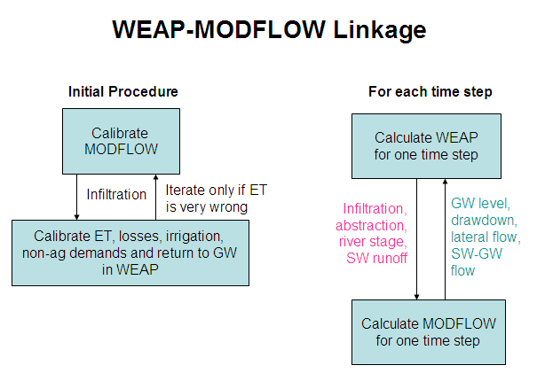
The following flow chart illustrates the flow of information between WEAP and MODFLOW.
The following topics describe the steps required to link WEAP to MODFLOW: Loading MODFLOW Model, Linking MODFLOW Cells to WEAP Elements and Running the Models and View Results. Also, see MODFLOW Link Technical Details.