WEAP can export the area schematic and results
in Google Earth format (.kmz). This
provides a powerful and convenient way to package the results from a WEAP
analysis to share with others -- everything is saved in one file that
can be sent via email or posted on a web site for others to download and
open in Google Earth. Here
are two examples from the Weaping River Basin (click to open in Google
Earth): Results
for each WEAP object, Animated
movie of results. Google
Earth is free and can be downloaded from http://earth.google.com
To export
to Google Earth requires that the WEAP area uses the WGS84 (lat/lon) or
UTM GIS projections. If
using the UTM projection, you will need to specify the UTM zone (1-60)
and hemisphere (north or south) on the "Save As" screen.
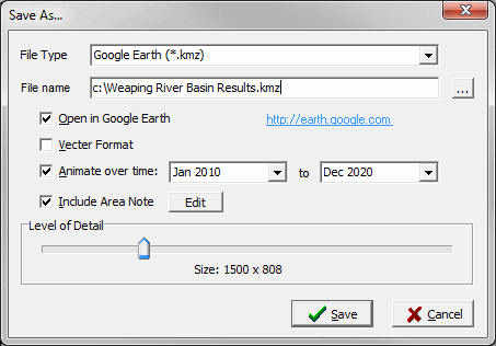
When saving to Google Earth,
a representation of the schematic will be displayed in Google Earth, georeferenced
so that it appears in the correct position over the Google Earth satellite
maps. In
the Schematic View (menu: Schematic,
Save Schematic to File), a schematic can be saved to Google Earth either
in "vector" or "raster" format. Vector
format will create individual clickable Google Earth elements for each
WEAP object (e.g., Rivers, Demand Sites, Reservoirs, Groundwater Nodes),
each of which can include any notes you've entered in the Notes
View. If
you uncheck "Vector Format," a single graphic image will be
exported to Google Earth, using the level of detail you choose. The
raster image will have a white background, and show the same spatial extent
as is currently shown in the Schematic window. (If you are zoomed in,
it will only show the zoomed in portion of the Schematic.) Additionally,
you can choose whether or not to include the note describing the entire
area; click the "Edit" button to see and edit the note. The
area note and the object
notes can include HTML formatting codes, which Google Earth will
display as if in a web browser. For
example, to include an image with a hyperlink (in this example, the WEAP
logo, linked to the WEAP web site), you would add the following text to
the note in WEAP: <a
href="http://www.weap21.org"><img src="http://www.weap21.org/img/logo8.gif"></a>
In the Results and Scenario Explorer Views, you can include results
with the schematic. Click
the
icon in the Chart Toolbar to open the
Save As window. When
saving from the Chart tab of the Results
View, WEAP will export the currently displayed chart, customized
for each relevant object. For
example, if the current chart is "Unmet Demand," then WEAP will
create a separate chart of Unmet Demand for each Demand Site and attach
each chart to the associated Demand Site. Click
on the Demand Site in Google Earth to see the chart. Because
each object must be clickable in Google Earth, only the vector format
is allowed.
When saving from the Map tab of the
Results View, WEAP will take whatever result variables that are
currently displayed on the WEAP map and create an animated
movie of results in Google Earth. Each timestep is a single frame
in the movie. Results
are shown on the map both as numeric labels and by varying the thickness
of lines or size of nodes, just as in WEAP. Increasing the Level
of Detail will yield sharper images, but will cause the Google
Earth kmz file to be larger. Because
the movie frames are raster images, only the raster format is allowed.
When saving from the Scenario Explorer
View, WEAP will export every currently displayed chart, customized
for each relevant object. If there are several charts for a given WEAP
object type, each will appear in the Google Earth note. For
example, if both "Supply Requirement" and "Unmet Demand"
are selected, then WEAP will create separate charts for Supply Requirement
and Unmet Demand for each Demand Site and attach them both to the each
Demand Site. Because
each object must be clickable in Google Earth, only the vector format
is allowed.
To summarize, here are the options for exporting to Google Earth:
Schematic View
Schematic only (no results); choice of vector or raster format.
Results View, Chart Tab
The current chart attached to every relevant WEAP object (in the notes
for each object); vector format.
Results View, Map Tab
Animated movie of results; raster format.
Scenario Explorer View
The current charts attached to every relevant WEAP object (in the notes
for each object); vector format.
 When saving to Google Earth,
a representation of the schematic will be displayed in Google Earth, georeferenced
so that it appears in the correct position over the Google Earth satellite
maps. In
the Schematic View (menu: Schematic,
Save Schematic to File), a schematic can be saved to Google Earth either
in "vector" or "raster" format. Vector
format will create individual clickable Google Earth elements for each
WEAP object (e.g., Rivers, Demand Sites, Reservoirs, Groundwater Nodes),
each of which can include any notes you've entered in the Notes
View. If
you uncheck "Vector Format," a single graphic image will be
exported to Google Earth, using the level of detail you choose. The
raster image will have a white background, and show the same spatial extent
as is currently shown in the Schematic window. (If you are zoomed in,
it will only show the zoomed in portion of the Schematic.) Additionally,
you can choose whether or not to include the note describing the entire
area; click the "Edit" button to see and edit the note. The
area note and the object
notes can include HTML formatting codes, which Google Earth will
display as if in a web browser. For
example, to include an image with a hyperlink (in this example, the WEAP
logo, linked to the WEAP web site), you would add the following text to
the note in WEAP: <a
href="http://www.weap21.org"><img src="http://www.weap21.org/img/logo8.gif"></a>
When saving to Google Earth,
a representation of the schematic will be displayed in Google Earth, georeferenced
so that it appears in the correct position over the Google Earth satellite
maps. In
the Schematic View (menu: Schematic,
Save Schematic to File), a schematic can be saved to Google Earth either
in "vector" or "raster" format. Vector
format will create individual clickable Google Earth elements for each
WEAP object (e.g., Rivers, Demand Sites, Reservoirs, Groundwater Nodes),
each of which can include any notes you've entered in the Notes
View. If
you uncheck "Vector Format," a single graphic image will be
exported to Google Earth, using the level of detail you choose. The
raster image will have a white background, and show the same spatial extent
as is currently shown in the Schematic window. (If you are zoomed in,
it will only show the zoomed in portion of the Schematic.) Additionally,
you can choose whether or not to include the note describing the entire
area; click the "Edit" button to see and edit the note. The
area note and the object
notes can include HTML formatting codes, which Google Earth will
display as if in a web browser. For
example, to include an image with a hyperlink (in this example, the WEAP
logo, linked to the WEAP web site), you would add the following text to
the note in WEAP: <a
href="http://www.weap21.org"><img src="http://www.weap21.org/img/logo8.gif"></a>