 WEAP uses a hierarchical structure to disaggregate
water demand data. You can easily adapt this structure to the nature of
your problem and data availability. A hypothetical example of a multilevel
demand structure is shown on the right.
WEAP uses a hierarchical structure to disaggregate
water demand data. You can easily adapt this structure to the nature of
your problem and data availability. A hypothetical example of a multilevel
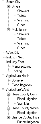
demand structure is shown on the right. WEAP uses a hierarchical structure to disaggregate
water demand data. You can easily adapt this structure to the nature of
your problem and data availability. A hypothetical example of a multilevel
demand structure is shown on the right.
The first level corresponds to the demand sites (from the Schematic created on the Schematic View). Below this, you can create as many levels as you wish. For example, South City is broken down into single and multifamily, and further by end use, while West City has no disaggregation. WEAP is flexible in allowing you to enter aggregated data initially, and to refine the demand projections later as more detailed data becomes available or necessary.
Examples of disaggregation:
Sector: A sample sectoral partition could include agriculture, industry, urban domestic and rural domestic. The sector categories can be used flexibly to correspond to the particular problem under analysis. The example at the right has no sectoral breakdown within a demand site--the demand sites themselves each represent one sector (two each for municipal, industry and agriculture).
Subsector: For example, the industrial sector could be divided into industrial classifications, e.g., steel and iron, petroleum, chemistry, textile, pulp and paper, and food processing. The agriculture sector might be broken down by crop type, livestock or another appropriate subsector.
End-use: For example, a crop end-use might be characterized by water requirements in different soil conditions or in different locations in the study area, or different irrigation techniques. Industrial end-uses might include processing, cooling and sanitary amenities.
Device: For example, sprinkler, drip or flooding irrigation in agricultural sectors, or showers, toilets, and washing for domestic sectors.
You can organize the demand tree along the lines of the available data. For example, under the agricultural sector, the irrigation area for each crop can be identified at the subsector level. One level down, the percentage of each irrigation technique in each crop may be assigned at the end-use level. Another equally valid way to organize the agriculture sector would be to identify irrigation districts at the subsector level and the crops grown within the irrigation districts at the end-use level.